PARKING AREA CLOSED UNTIL FURTHER NOTICE DUE TO RAIN DAMAGE (5/8/25)
100 Fern Avenue, Litchfield, CT 06759
90 acres
Roundtrip Distance: 1 mile
Easy walking, but often wet. The Yellow Trail round trip is about 1 mile in length.
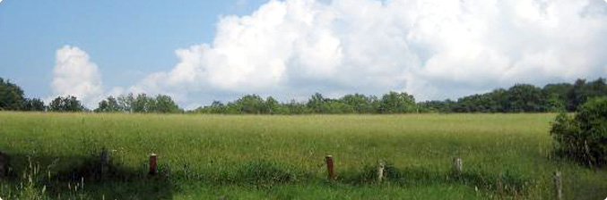
The creation of the Hauser Nature Preserve in the mid-1970s was a decisive step by Gustave and Rita Hauser to preserve some of Litchfield’s highest and most developable land. Much of the land is farmed; including a tract 1/4 mile south of the mapped parcel (since grazing occurs there it is not open to the public). The defining character of the park is a hayfield, but it also features a woodland, increased by Mr. and Mrs. George Weston’s gift of 36 acres at the northeast corner. Higher than Litchfield’s village center, the hayfield looks out to the high points of the Litchfield Hills, including Cornwall’s Mohawk Mountain. By virtue of the poorly drained soils, the hayfield usually can’t be cut until after mid-July. This has been a saving grace to one of Connecticut’s populations of bobolinks, a declining species. They require unmowed meadow for breeding before migrating to Argentina. In addition to the breeding grounds, the hayfield appears to be a major pre-migration staging ground for area bobolinks that are displaced by mowing elsewhere in the vicinity. Timothy and reed canary grass seeds fatten them for their long journey. Bobolinks can be seen here from mid-May through July; dogs are prohibited during the nesting season.
While it is satisfying to explore the hayfield, the woodland on the north offers the Ed Eveleth Memorial Trail, which loops through the headwaters of a brook with exposed stones reflecting the unique geology beneath most of Litchfield’s soils. Milky quartz appears here with the tease of potential gold deposits. Because this area is contiguous with Topsmead State Forest, wildlife thrives in this area. Ed Eveleth was a major influence in keeping the lives of busy Litchfield County residents healthy and in touch with the natural world. He volunteered for many organizations and outfitted thousands of locals and visitors with equipment and knowledge to enjoy the beauty of the region. Northwest Connecticut Land Conservancy hopes you will feel his energy on this path and use it, like Ed, as a true keeper of this special area. To reach the Eveleth Trail, walk along the left (north) side of the hayfield past the crest of the hill and watch for square yellow markers at a gap in the treeline. An old trail created by the neighbors cuts north into the woods before the crest of the hill.